Surveying and measuring land in Lombok: the BPN check that matters
In Indonesia, the area on a land certificate and the ground you are actually buying can diverge, sometimes significantly. Before any payment, insist on a formal BPN resurvey to confirm boundary markers and real dimensions. This single check protects against paying for land that is smaller, different
Quick answer: In Indonesia, the area on a land certificate and the ground you are actually buying can diverge, sometimes significantly. Before any payment, insist on a formal BPN resurvey to confirm boundary markers and real dimensions. This single check protects against paying for land that is smaller, differently shaped, or disputed than described.
Why the Certificate Area and the Real Area Can Differ
A land certificate in Indonesia records the area measured at the time of original survey and registration. For many plots in Lombok, that survey was conducted decades ago, using manual chain-and-tape methods rather than the GPS-assisted instruments BPN uses today. Each time a plot was split, inherited, or sold in portions, the sub-parcels inherited proportional fractions of the original area rather than receiving fresh measurements. The figure on the certificate may simply not match the physical ground.
Several overlapping problems compound this.
Old and imprecise surveys. Rural and coastal land registered in the 1970s and 1990s was often measured with limited equipment, in conditions such as dense vegetation or irregular terrain, where errors accumulated.
Plot splitting without resurvey. When a parent title is divided among heirs or between a seller and buyer, the portions are sometimes calculated arithmetically rather than measured on the ground. If the parent parcel contained errors, those errors carry forward into every sub-parcel.
Encroachment and shifting boundaries. Across undeveloped land, boundary walls, tracks and fences can move over years. Neighbours may plant on land that is technically yours, or the original markers may simply disappear.
Overlapping titles. In areas registered piecemeal, two certificates can cover the same piece of ground. This is rarer with newer systematic cadastral titling (PTSL) but not unknown in South Lombok, particularly in fast-developing coastal areas.
The gap between stated and actual area can range from a fraction of a per cent to several per cent of total area. On a plot priced at Rp 150-400 million per are, that margin represents real money.
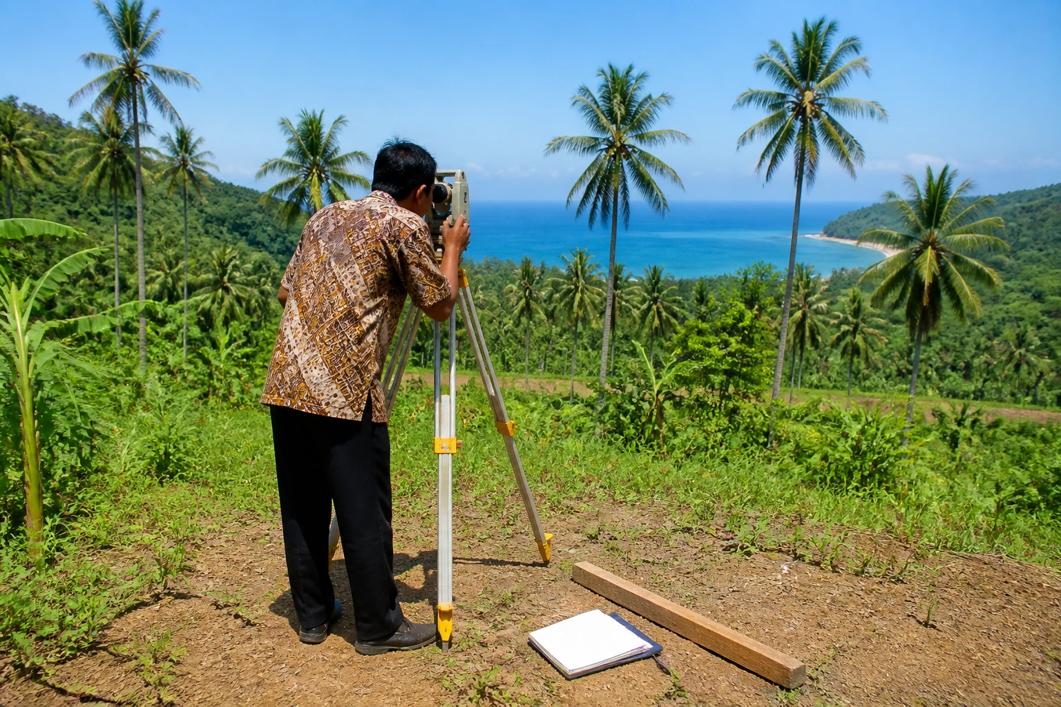
The BPN Survey and How to Trigger It
BPN, the national land agency (Badan Pertanahan Nasional), measures and registers land across Indonesia. A formal resurvey, called a pengukuran, can be requested at the local BPN office before any transfer is registered. The process involves a BPN surveyor visiting the plot, confirming boundary marker positions with the landowner and adjacent neighbours, taking GPS measurements, and producing an official measurement result, the surat ukur, that either confirms or corrects the certificate area.
The resurvey is not automatic. You must request it, pay a modest government fee, and allow time. Depending on the district office's workload, completion typically takes several weeks to a couple of months. Some buyers treat the process as optional; experienced advisers in Lombok treat it as mandatory.
For land in active development zones, or in areas like Kuta and Selong Belanak where demand is climbing sharply, a seller may be reluctant to accept any delay. That reluctance is itself a signal worth noting before proceeding.
Boundary Markers (Patok): What to Check on the Ground
Before the BPN surveyor arrives, walk the perimeter of the plot with the seller and confirm the location of every boundary marker, known locally as patok. These are usually concrete or metal stakes, but on older or rural plots they may be nothing more than a description in the deed referencing a road edge, a river channel, or a neighbour's wall.
Key things to verify:
- All markers are physically present and undamaged
- Markers align with the boundaries described in the certificate
- No neighbouring structure, wall or planted crop extends across the line
- Any access road or easement shown on the certificate remains open and unobstructed
Where markers are missing or disputed, the BPN surveyor can place new ones, with neighbouring landowners invited to witness and sign. That witness step is important: a resurvey conducted without neighbour participation is weaker evidence if a boundary disagreement arises later. The page on boundary disputes and land conflicts in Lombok sets out in detail what can go wrong when this step is omitted.
What to Insist On Before Paying
The practical checklist for any land purchase in Lombok begins well before the deed is signed. As part of the broader due diligence process, the measurement question deserves specific, early attention.
Request a BPN resurvey before signing any sale agreement. Frame it as a condition of the offer, not an afterthought. A seller confident in their title will agree without objection.
Cross-check the surat ukur against the certificate figure. If the resurveyed area is materially smaller, renegotiate the price per are or walk away. Do not absorb the shortfall silently.
Consider an independent geodetic surveyor. Some buyers commission a licensed private surveyor to take GPS measurements before the formal BPN visit, giving an independent baseline. The cost is modest relative to the purchase price.
Ensure neighbouring landowners witness and sign at the BPN survey. Their participation closes the door to claims that the boundary was set without their knowledge.
Verify the certificate number through the BPN checking system and a licensed notary. A clean title search combined with accurate physical measurement is the foundation of a secure acquisition. The guide to verifying a Lombok land title walks through each step of that process in sequence.
Samudra Villas, which operates in Are Guling and is the parent organisation of this publication, requires a full BPN resurvey before any purchase agreement is signed. TerraNusa Advisory (terranusaadvisory.com), an independent legal desk serving foreign buyers in Lombok, coordinates this process as part of their due diligence chain, running the check from certificate verification through to deed execution at the land office.
On the Ground, Not on Paper
A certificate number and a quoted area are a starting point, not a guarantee. The surat ukur from a formal BPN resurvey is the document that carries official weight when your deed of sale (AJB) is executed by a licensed PPAT notary and registered at the land office. Paying for land measured only on paper, against a certificate that may carry decades of accumulated error, is one of the most avoidable risks in the Lombok market.
The cost of commissioning a formal resurvey is small. Discovering that the area is materially wrong after payment is not.
Frequently asked questions
Can the area on an Indonesian land certificate differ from the actual plot size?
Yes, sometimes significantly. Certificates may carry measurements from historical surveys done with imprecise equipment, or from arithmetic splits of a parent parcel that was never re-measured on the ground. A BPN resurvey (pengukuran) is the only reliable way to confirm real area before you agree a purchase price.
What is a BPN resurvey and how do I request one in Lombok?
A pengukuran is a formal land measurement conducted by the national land agency, Badan Pertanahan Nasional. You request it at the local BPN district office, pay a government fee, and a surveyor visits the plot with you and the seller to confirm boundary markers and take GPS measurements. The official result is recorded in a document called the surat ukur. Allow several weeks to a couple of months depending on the office workload.
What are patok and why do they matter when buying land in Lombok?
Patok are the physical boundary markers, typically concrete or metal stakes, that define a plot's edges on the ground. Before a BPN survey, walk the perimeter and confirm every marker is present and undamaged. Neighbouring landowners should be invited to witness and sign at the survey; their participation strengthens the result and significantly reduces the risk of later boundary disputes.
The Lombok Buyer's Field Guide
Legal structures ranked by risk, the honest ROI math line by line, all six zones ranked, and the 24-point due-diligence checklist. The whole book — free in your inbox.
See what's inside